


A personal message from Oregon Chang

Have you had a close encounter story or witnessed something unusual that you would like to share?
Do you wish to collaborate with Asia Paranormal through link or content exchange?
Do you have any enquiries or feedback?
Email us at AsiaParanormal@gmail.com
We look forward to hearing from you!
Follow us on


Vote for us!
Best regards, on behalf of team AsiaParanormal
Do you wish to collaborate with Asia Paranormal through link or content exchange?
Do you have any enquiries or feedback?
Email us at AsiaParanormal@gmail.com
We look forward to hearing from you!
Follow us on
Vote for us!
Best regards, on behalf of team AsiaParanormal
Master Orthodox Occultist Oregon Chang, The 17th generation Disciple
of Seven Stars Sword Master Hebei China
Showing posts with label Earth Mysteries. Show all posts
Showing posts with label Earth Mysteries. Show all posts
Tuesday, October 9, 2012

Monday, October 8, 2012
Something Strange spotted in Gobi desert

The objects were spotted using Google Maps and resulted in a substantial amount of speculation – especially among conspiracy theorists. Could we be looking at China’s equivalent of Area 51? Or signs of an ancient lost civilization? Or some form of guidance system for alien spacecraft? Or …?
[Click here to read full article]
Friday, August 10, 2012
Abraham Lincoln face appears in Clouds

It usually takes a little bit of Hollywood magic to convincingly make a cloud look like a person's face, but a man in New Brunswick, Canada might have seen the real thing.
In the video , shot by YouTube user "denisfarmer" and posted on accuweather.com, the clouds are moving fast, which is actually pretty typical for a big storm front like this one. As they do, a man's profile seems to emerge, and even resembles Abraham Lincoln at one point.
[Click here to read full article]
Thursday, July 12, 2012
Sinkholes in China: July 2012
The official explanation is over-development but why would all these sinkholes show up more frequently in different parts of the world since last year? Here’re some of the key events:
Intense solar storms–> large amount of energy absorbed by the earth’s crust due to earth’s weakening magnetic field –> the earth’s core heats up –> the earth’s crust starts the process of breaking apart from the shifting of the inner core against its mass, active fault lines –> the planet opens relief fissures to handle the pressures exerted –> sinkholes, mysterious sounds –> earthquakes, volcanic eruptions etc –> Global Earthquake
[Click here to read full article]
Read more >>
Intense solar storms–> large amount of energy absorbed by the earth’s crust due to earth’s weakening magnetic field –> the earth’s core heats up –> the earth’s crust starts the process of breaking apart from the shifting of the inner core against its mass, active fault lines –> the planet opens relief fissures to handle the pressures exerted –> sinkholes, mysterious sounds –> earthquakes, volcanic eruptions etc –> Global Earthquake
[Click here to read full article]
Friday, March 9, 2012
Beirut River mysteriously runs blood red
BEIRUT: The Beirut River mysteriously turned blood red Wednesday after a stream of unidentified red liquid began pouring from the southern bank of the river in Furn al-Shubbak. The source of the liquid had yet to be determined Wednesday evening, as the river continued to empty the red-colored water into the Mediterranean Sea.

Government and local officials rushed to the scene at the Chevrolet crossing of Furn al-Shubbak Wednesday morning in an attempt to locate the sewage canal that was dumping the red-colored water but they were unable to locate the source. Accusations were traded among officials from the municipalities of Hadath, Hazmieh, Sin al-Fil, Furn al-Shubbak and Shiyah.
Eyewitnesses working in the area told The Daily Star this was not the first time the river had turned a different color. Several business owners around the Chevrolet crossing said that colored water pours into the river roughly every two months but no one pays attention to it.It was the quantity and brightness of the red liquid that grabbed the attention of many passersby and commuters on different bridges in the city Wednesday.
Environment Minister Nazem Khoury said the source of the water was likely from Hazmieh or Baabda.
“I call on the municipalities of Hazmieh and Baabda to cooperate swiftly to find the source of the pollution and its type,” Khoury said in a statement.
Earlier in the day, Khoury sent an environmental team to the area to examine the water. The team, headed by ministry official Bassam Sabbagh, took a sample of the water to determine its composition and whether it contained dangerous pollutants.
[Click here to read full article]
Read more >>

Government and local officials rushed to the scene at the Chevrolet crossing of Furn al-Shubbak Wednesday morning in an attempt to locate the sewage canal that was dumping the red-colored water but they were unable to locate the source. Accusations were traded among officials from the municipalities of Hadath, Hazmieh, Sin al-Fil, Furn al-Shubbak and Shiyah.
Eyewitnesses working in the area told The Daily Star this was not the first time the river had turned a different color. Several business owners around the Chevrolet crossing said that colored water pours into the river roughly every two months but no one pays attention to it.It was the quantity and brightness of the red liquid that grabbed the attention of many passersby and commuters on different bridges in the city Wednesday.
Environment Minister Nazem Khoury said the source of the water was likely from Hazmieh or Baabda.
“I call on the municipalities of Hazmieh and Baabda to cooperate swiftly to find the source of the pollution and its type,” Khoury said in a statement.
Earlier in the day, Khoury sent an environmental team to the area to examine the water. The team, headed by ministry official Bassam Sabbagh, took a sample of the water to determine its composition and whether it contained dangerous pollutants.
[Click here to read full article]
Monday, February 6, 2012
This amazing video shows a split in the water in the seas of Hong Kong. What sort of paranormal or earthly forces can cause this?
Read more >>
Wednesday, February 1, 2012
Strange Sounds In The Sky All Around The World
Do you have an explanation for all of the strange sounds in the sky that have been documented all around the world lately? Over the past few weeks, Twitter, Facebook and the blogosphere have been absolutely buzzing about these strange sounds. At the moment, they remain a great mystery because nobody can seem to explain them. Some are calling them "apocalyptic sounds". Whatever they are, they are very loud.
Those that have heard the unexplained sounds in the sky compare them to the rumbling of a train, a sonic boom or a trumpet. In this article, we will discuss some of the most popular theories about these sounds, but the truth is that right now nobody really knows what is going on. But what we can say is that this is truly a global phenomenon. Strange sounds in the sky are being recorded literally all over the world and are being uploaded to YouTube at a very rapid pace. If someone was trying to fake this, it would be quite difficult to get people all over the planet to cooperate. In some instances, entire communities have heard these sounds.
So it appears as though something is definitely happening. Perhaps there is a very basic explanation for all of this. Perhaps there is not. In any event, the fact that we simply do not know what is going on is rather unsettling.
Read more >>
Those that have heard the unexplained sounds in the sky compare them to the rumbling of a train, a sonic boom or a trumpet. In this article, we will discuss some of the most popular theories about these sounds, but the truth is that right now nobody really knows what is going on. But what we can say is that this is truly a global phenomenon. Strange sounds in the sky are being recorded literally all over the world and are being uploaded to YouTube at a very rapid pace. If someone was trying to fake this, it would be quite difficult to get people all over the planet to cooperate. In some instances, entire communities have heard these sounds.
So it appears as though something is definitely happening. Perhaps there is a very basic explanation for all of this. Perhaps there is not. In any event, the fact that we simply do not know what is going on is rather unsettling.
Thursday, December 29, 2011
Does the Sadahurip Mountain in Garut, West Java hide a pyramid?
Archaeologists are looking at Sadahurip Mountain in Garut, West Java. The great mystery awaits to be unveiled: is it true that the mountain contains a huge pyramid of which size is more superior to Giza Pyramid in Egypt? In Bosnia, six years ago in 2005, a hill named Visocica gained fame.
An archaeology enthusiast and businessman, Semir Osmanagic, found unusual appearance on the shape of the 213-meter high hill in April 2005.
A series of excavations were carried out to further answer the assumption. He claimed that a number of covert rock incriptions were spotted. Final excavation brought to light that the pyramid located in the hill was larger that the Giza.
Archaeologists were against the finding. However, Osmanagic was not hesitant. "They're just jealous," he told LiveScience. "They have taught students that the ancient Bosnians were cavemen. And out of a sudden, a complex man-made structure is found."
Is the finding in Garut inspired by the similar discovery in Bosnia?
Member of Ancient Catastrophic Disaster Team, Iwan Sumule, said no to the posit.
"The Garut pyramid was found by chance as the team looked into faults and the annals of past earthquakes," he told VIVAnews.
Iwan said earthquakes are considered recurring events with periodic time, including volcanoes.
"It is believed that the extinct human civilization was due to past disasters like earthquakes and volcano eruptions."
[Click here to read full article]
Read more >>
An archaeology enthusiast and businessman, Semir Osmanagic, found unusual appearance on the shape of the 213-meter high hill in April 2005.
A series of excavations were carried out to further answer the assumption. He claimed that a number of covert rock incriptions were spotted. Final excavation brought to light that the pyramid located in the hill was larger that the Giza.
Archaeologists were against the finding. However, Osmanagic was not hesitant. "They're just jealous," he told LiveScience. "They have taught students that the ancient Bosnians were cavemen. And out of a sudden, a complex man-made structure is found."
Is the finding in Garut inspired by the similar discovery in Bosnia?
Member of Ancient Catastrophic Disaster Team, Iwan Sumule, said no to the posit.
"The Garut pyramid was found by chance as the team looked into faults and the annals of past earthquakes," he told VIVAnews.
Iwan said earthquakes are considered recurring events with periodic time, including volcanoes.
"It is believed that the extinct human civilization was due to past disasters like earthquakes and volcano eruptions."
[Click here to read full article]
Monday, December 26, 2011
It's Official: Stonehenge Stones Were Moved 160 Miles
Dave Mosher
for National Geographic News
Some of the volcanic bluestones in the inner ring of Stonehenge officially match an outcrop in Wales that's 160 miles (257 kilometers) from the world-famous site, geologists announced this week. (See Wales pictures.)
The discovery leaves two big ideas standing about how the massive pieces of the monument arrived at Salisbury Plain: entirely by human hand, or partly by glacier.
As it looks today, 5,000-year-old Stonehenge has an outer ring of 20- to 30-ton sandstone blocks and an inner ring and horseshoe of 3- to 5-ton volcanic bluestone blocks. (See Stonehenge pictures.)
The monument's larger outer blocks, called the Sarsen stones, were likely quarried some 20 to 30 miles (32 to 48 kilometers) away in what's now England, where sandstone is a common material.
The origin of the bluestones, however, has weighed heavy on the hearts of archaeologists. Rocks resembling the material under a microscope haven't been found anywhere relatively near Stonehenge—at least until now.
Pinpointing the stones' origins is crucial to understanding how so many heavy hunks of rock made their way to the open plain where Stonehenge now stands.
"There's no way of explaining how these stones were transported without knowing where they came from," said study co-author Robert Ixer of the University of Leicester in the U.K.
[Click here to read full article]
Read more >>
for National Geographic News
Some of the volcanic bluestones in the inner ring of Stonehenge officially match an outcrop in Wales that's 160 miles (257 kilometers) from the world-famous site, geologists announced this week. (See Wales pictures.)
The discovery leaves two big ideas standing about how the massive pieces of the monument arrived at Salisbury Plain: entirely by human hand, or partly by glacier.
As it looks today, 5,000-year-old Stonehenge has an outer ring of 20- to 30-ton sandstone blocks and an inner ring and horseshoe of 3- to 5-ton volcanic bluestone blocks. (See Stonehenge pictures.)
The monument's larger outer blocks, called the Sarsen stones, were likely quarried some 20 to 30 miles (32 to 48 kilometers) away in what's now England, where sandstone is a common material.
The origin of the bluestones, however, has weighed heavy on the hearts of archaeologists. Rocks resembling the material under a microscope haven't been found anywhere relatively near Stonehenge—at least until now.
Pinpointing the stones' origins is crucial to understanding how so many heavy hunks of rock made their way to the open plain where Stonehenge now stands.
"There's no way of explaining how these stones were transported without knowing where they came from," said study co-author Robert Ixer of the University of Leicester in the U.K.
[Click here to read full article]
Wednesday, December 7, 2011
Fukushima Earthquake Moved Seafloor Half a Football Field
By Mark Fischetti
The March 2011 Tohoku-Oki earthquake that decimated Japan and its Fukushima nuclear reactors with a monster tsunami altered the seafloor off the country’s eastern coast much more than scientists had thought. Analysis released today in the journal Science indicates the ocean bed moved as much as 50 meters laterally and 16 meters vertically. The magnitude 9.0 quake occurred close to the nearby Japan Trench that runs north to south in the Pacific Ocean (dark blue line on the map below).
The trench exists because the oceanic Pacific Plate (dark blue on map below) is moving westward, hitting and bending down under the continental Okhotsk Plate (light blue) from which Japan rises (green, brown). This “subduction” action creates tension within the tectonic plates, which is occasionally released in the form of earthquakes.
Although measurements from satellites and seismic ground sensors had indicated the Okhotsk Plate moved after the 9.0 temblor on March 11, the extent of the movement was not clear. Researchers at the Japan Agency for Marine-Earth Science and Technology compared new seafloor maps made of the region this year with maps made in 1999 and were surprised by the extent of motion. For example, data along one transect (yellow marker, below) near the quake’s epicenter (black “x” on the map) indicated that the Okhotsk plate moved 50 meters east-southeast toward the trench.
[Click here to read full article]
Read more >>
The March 2011 Tohoku-Oki earthquake that decimated Japan and its Fukushima nuclear reactors with a monster tsunami altered the seafloor off the country’s eastern coast much more than scientists had thought. Analysis released today in the journal Science indicates the ocean bed moved as much as 50 meters laterally and 16 meters vertically. The magnitude 9.0 quake occurred close to the nearby Japan Trench that runs north to south in the Pacific Ocean (dark blue line on the map below).
The trench exists because the oceanic Pacific Plate (dark blue on map below) is moving westward, hitting and bending down under the continental Okhotsk Plate (light blue) from which Japan rises (green, brown). This “subduction” action creates tension within the tectonic plates, which is occasionally released in the form of earthquakes.
Although measurements from satellites and seismic ground sensors had indicated the Okhotsk Plate moved after the 9.0 temblor on March 11, the extent of the movement was not clear. Researchers at the Japan Agency for Marine-Earth Science and Technology compared new seafloor maps made of the region this year with maps made in 1999 and were surprised by the extent of motion. For example, data along one transect (yellow marker, below) near the quake’s epicenter (black “x” on the map) indicated that the Okhotsk plate moved 50 meters east-southeast toward the trench.
[Click here to read full article]
Saturday, November 26, 2011
Mount Doom: Don't say we didn't warn you
by Sarah Simpson
One of today’s most dangerous volcanoes is one you’ve probably never heard about. The North Koreans call it Paektu; the Chinese call it Changbai. In a headline Friday, Science called it Mount Doom.
The picturesque, lake-topped peak, which straddles the border between North Korea and China, “explodes to life every 100 years or so, the last time in 1903,” reports Science’s Richard Stone, who visited Mount Doom in September with two volcanologists from the U.K.
The volcano’s most dramatic eruption rivaled the famous 1815 Tambora eruption in Indonesia, Stone writes, and it could unleash more of the same:
“Around 1000 years ago, the volcano rained tephra—pumice and ash—across 33,000 square kilometers of northeast China and Korea, dumping 5 centimeters of ash as far away as Japan…. Because Changbai's silica-rich magma is viscous and gassy, allowing pressure to build, the next eruption should be explosive.”
If a similar eruption occurred today, 100,000 people would be vulnerable to avalanches of superheated gas, rock and ash called pyroclastic flows. Even a much smaller eruption could catastrophically drain the deep lake that now sits atop the mountain. Mixed with rocks, mud and vegetation, all that water would become a soupy stew called a lahar, which would hurtle down the lake’s single outlet, a narrow valley on the Chinese side where 60,000 people reside.
University of Oregon supervolcano expert Ilya Bindeman has had his eye on Changbai-Paektu for some time. “It’s not quite a supervolcano, but close,” he told Discovery News. Like Tambora, Changbai-Paektu is a 7 on the scale of known eruptions; a true supervolcano is an 8. Bindeman says only five regions have experienced supereruptions in the past two million years: Yellowstone and Long Valley in the western U.S., Toba in Sumatra, Taupo in New Zealand and Kamchatka in Russia, which Bindeman and his colleagues only recently discovered.
[Click here to read full article]
Read more >>
One of today’s most dangerous volcanoes is one you’ve probably never heard about. The North Koreans call it Paektu; the Chinese call it Changbai. In a headline Friday, Science called it Mount Doom.
The picturesque, lake-topped peak, which straddles the border between North Korea and China, “explodes to life every 100 years or so, the last time in 1903,” reports Science’s Richard Stone, who visited Mount Doom in September with two volcanologists from the U.K.
The volcano’s most dramatic eruption rivaled the famous 1815 Tambora eruption in Indonesia, Stone writes, and it could unleash more of the same:
“Around 1000 years ago, the volcano rained tephra—pumice and ash—across 33,000 square kilometers of northeast China and Korea, dumping 5 centimeters of ash as far away as Japan…. Because Changbai's silica-rich magma is viscous and gassy, allowing pressure to build, the next eruption should be explosive.”
If a similar eruption occurred today, 100,000 people would be vulnerable to avalanches of superheated gas, rock and ash called pyroclastic flows. Even a much smaller eruption could catastrophically drain the deep lake that now sits atop the mountain. Mixed with rocks, mud and vegetation, all that water would become a soupy stew called a lahar, which would hurtle down the lake’s single outlet, a narrow valley on the Chinese side where 60,000 people reside.
University of Oregon supervolcano expert Ilya Bindeman has had his eye on Changbai-Paektu for some time. “It’s not quite a supervolcano, but close,” he told Discovery News. Like Tambora, Changbai-Paektu is a 7 on the scale of known eruptions; a true supervolcano is an 8. Bindeman says only five regions have experienced supereruptions in the past two million years: Yellowstone and Long Valley in the western U.S., Toba in Sumatra, Taupo in New Zealand and Kamchatka in Russia, which Bindeman and his colleagues only recently discovered.
[Click here to read full article]
Friday, November 18, 2011
What are these mysterious lines in China's desert?

A strange tangle of white lines in the Chinese desert has people scratching their heads and wondering who made them—and why. According to a Gizmodo post “Why Is China Building These Gigantic Structures In the Middle of the Desert?”
New photos have appeared in Google Maps showing unidentified titanic structures in the middle of the Chinese desert. The first one is an intricate network of what appears to be huge metallic stripes. Is this a military experiment? They seem to be wide lines drawn with some white material. Or maybe the dust have been dug by machinery. It's located in Dunhuang, Jiuquan, Gansu, north of the Shule River, which crosses the Tibetan Plateau to the west into the Kumtag Desert. It covers an area approximately one mile long by more than 3,000 feet wide. The tracks are perfectly executed, and they seem to be designed to be seen from orbit.
In examining this mystery there are a few things that should be cleared up. First of all, contrary to the Gizmodo headline, it's not clear that the image depicts “structures” at all. Because of the angle at which the image is photographed, the lines may simply be flat, like roads. In fact a close look at the image reveals that the lines appear to have sand blown over them in places, suggesting that they indeed have a smooth surface and are low to the ground.
The suggestion that the lines were created to be seen from space is dubious at best. An identical claim is often made for the Nazca lines, in the Atacama desert of Peru. Those lines, also, are sometimes said to have been designed to be seen from space (one favored—and thoroughly discredited—theory was that the lines were created for visiting extraterrestrials).
[Click here to read full article]
Tuesday, November 8, 2011
More weird images captured by Google Earth
Weird images captured by Google Earth

The Osmington White Horse, outside Sutton Poyntz, UK. This prehistoric figure is carved into the white chalk of the hillside – such horse carved shapes are called “Leucippotomy”.

Heart-shaped island highlighted by Google Earth becomes hit with lovers
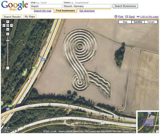
Land Art or “Earth Art” appearing in a field near the airport in Munich, Germany.
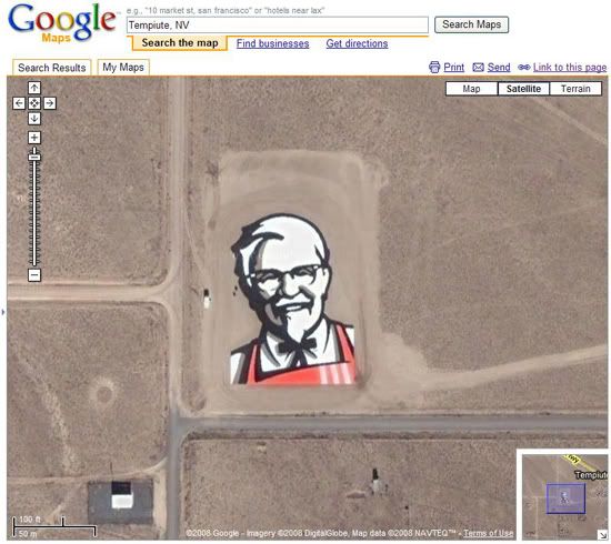
Yum! Brands Inc created the logo near Rachel, Nevada, and claimed it’s the first ad that can be seen from space. If you recall, the same company had previously wanted to beam a laser ad up onto the moon for Pizza Hut, but had later scaled back to buying ad placement on the side of a Russian rocket.

Marriage proposal seen on a rooftop via Google Maps.

Out of some sort of fear that they might forget who he was, the people of Mongolia have carved the likeness of Ghenghis Khan onto a hillside outside of Ulaanbaatar.
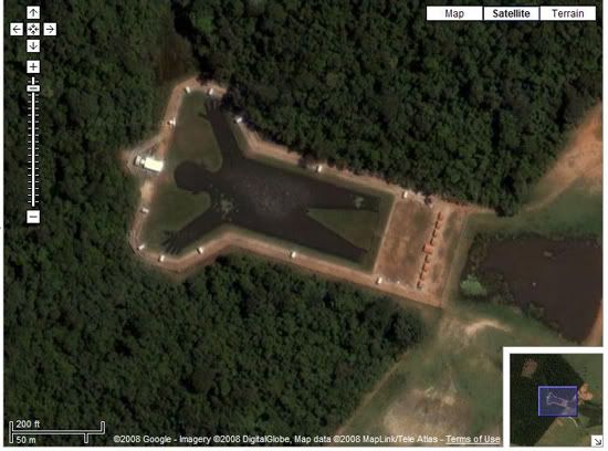
Man-Shaped Lake in Brazil

The Palm Islands are artificial islands in Dubai, United Arab Emirates on which major commercial and residential infrastructure will be constructed. They are being constructed by Nakheel Properties, a property developer in the United Arab Emirates, who hired Belgian and Dutch dredging and marine contractor Jan De Nul and Van Oord, some of the world’s specialists in land reclamation. The islands are the Palm Jumeirah, the Palm Jebel Ali and the Palm Deira.

Without a doubt, the best thing that ever happened to crop circles is Google Earth. This circle in the desert just outside Beatty, Nevada (Google Earth coordinates 37.401437,-116.86773), is one of hundreds spotted with the software.

As if Oprah Winfrey's celebrity weren't big enough already, an Arizona farmer built a 10-acre homage to the talk show host (Google Earth coordinates 33.225488,-111.5955). Visitors can tell their friends, "I got lost inside Oprah's head.
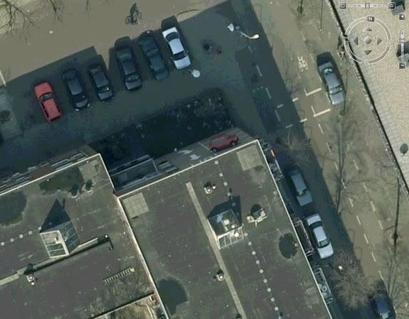
Think parking is tough where you live? In Westenbergstraat, Netherlands, drivers apparently have to park on the sides of walls (Google Earth coordinates 52.069207,4.3139865).

ome of the sights you find in Google Earth are just plain mysterious. For example, why is a fighter jet parked (Google Earth coordinates 48.825183,2.1985795) in what looks to be a residential neighborhood lot near Paris?

A mysterious pattern of white lines found in Norwich, UK (52.481725, 0.520627) (see it on Google Maps) [zoom to image] has prompted some Fox Mulder fans to say "I want to believe."

Likened to the face of Mother Earth, these kilometre-wide pair of Angelina Jolie-style lips can be found in the Sudanese region of West Darfur. The sides of the rocky canyon are about 40 meters high giving it the pout look.
Read more >>
The Osmington White Horse, outside Sutton Poyntz, UK. This prehistoric figure is carved into the white chalk of the hillside – such horse carved shapes are called “Leucippotomy”.
Heart-shaped island highlighted by Google Earth becomes hit with lovers
Land Art or “Earth Art” appearing in a field near the airport in Munich, Germany.
Yum! Brands Inc created the logo near Rachel, Nevada, and claimed it’s the first ad that can be seen from space. If you recall, the same company had previously wanted to beam a laser ad up onto the moon for Pizza Hut, but had later scaled back to buying ad placement on the side of a Russian rocket.
Marriage proposal seen on a rooftop via Google Maps.
Out of some sort of fear that they might forget who he was, the people of Mongolia have carved the likeness of Ghenghis Khan onto a hillside outside of Ulaanbaatar.
Man-Shaped Lake in Brazil
The Palm Islands are artificial islands in Dubai, United Arab Emirates on which major commercial and residential infrastructure will be constructed. They are being constructed by Nakheel Properties, a property developer in the United Arab Emirates, who hired Belgian and Dutch dredging and marine contractor Jan De Nul and Van Oord, some of the world’s specialists in land reclamation. The islands are the Palm Jumeirah, the Palm Jebel Ali and the Palm Deira.
Without a doubt, the best thing that ever happened to crop circles is Google Earth. This circle in the desert just outside Beatty, Nevada (Google Earth coordinates 37.401437,-116.86773), is one of hundreds spotted with the software.
As if Oprah Winfrey's celebrity weren't big enough already, an Arizona farmer built a 10-acre homage to the talk show host (Google Earth coordinates 33.225488,-111.5955). Visitors can tell their friends, "I got lost inside Oprah's head.
Think parking is tough where you live? In Westenbergstraat, Netherlands, drivers apparently have to park on the sides of walls (Google Earth coordinates 52.069207,4.3139865).
ome of the sights you find in Google Earth are just plain mysterious. For example, why is a fighter jet parked (Google Earth coordinates 48.825183,2.1985795) in what looks to be a residential neighborhood lot near Paris?
A mysterious pattern of white lines found in Norwich, UK (52.481725, 0.520627) (see it on Google Maps) [zoom to image] has prompted some Fox Mulder fans to say "I want to believe."
Likened to the face of Mother Earth, these kilometre-wide pair of Angelina Jolie-style lips can be found in the Sudanese region of West Darfur. The sides of the rocky canyon are about 40 meters high giving it the pout look.
Monday, November 7, 2011
Mystery of Mount Anak Krakatau
Krakatoa is one of the most famous volcanoes in the world. In 1883, the volcano that located in Sunda Strait had a catastrophic eruption that destroyed almost the entire island. Since then, the volcano has been rebuilding itself and now Anak Krakatau (Child of Krakatoa) has emerged and has been growing above water since 1927.
In the book “Javanese Book of Kings”, noted that Mount Old Krakatoa in the Sunda Strait Indonesia have 2,000 meters high above sea level with a radius of 11 km. Great eruption that occurred about 416 AD destroyed three quarters of the island and left 3 small islands namely Sertung Island, Rakata Island, and Panjang Island, as well as a caldera in centre of three islands. Next comes two mountains named Mount Danan and Mount Perbuatan which then eventually unite with the Rakata Island then commonly referred as Mount Krakatoa.
On August 27, 1883 This Mount Krakatoa erupted very terrible and shocking the world. This eruption mentioned as The Deadliest Volcano after Mount Tambora Eruption. Shot of lava reached an altitude of 80 km, eruptive sound was heard in Singapore and Australia. Krakatoa eruption also caused a series of earthquakes which spread to Australia, Sri Lanka and the Philippines. His ashes around the earth for several years. Viewed from North America and Europe, when it became visible light is blue and the moon appears orange (orange).
Krakatoa eruption produced great dust that can penetrate up to 90 km distance. The eruption was also causing sea waves or tsunami as high as 40 m and a clean sweep of about 165 villages in Lampung and Banten, and about 36,000 people missing. Then Mount Danan and Perbuatan destroyed an only leaving the three islands of Panjang, Sertung, and Rakata Besar and also a caldera with a diameter of 7 km located in the middle of these islands.
1927, Forty-four years later was born the precursor of Anak Krakatau. The fishermen in the Sunda Strait suddenly surprised by the appearance of black smoke at sea level between the three islands. Then on the 29th december 1929 a crater wall appears to sea level which is also a source of eruptions. The rose of Mount Anak Krakatau, which until now continues to grow around 5 inches (13 cm) per week. Mount Anak Krakatoa which was originally only a few feet away, now it can reach 315 meters above sea level.
Mount Anak Krakatoa is still active , since Desember 1927 recorded has erupted about 75 times. The Most recent is on November 1, 2010 Mount Anak Krakatoa showing some spectacular eruption with hot gases, rocks, and lava released.
[Click here to read full article]
Read more >>
In the book “Javanese Book of Kings”, noted that Mount Old Krakatoa in the Sunda Strait Indonesia have 2,000 meters high above sea level with a radius of 11 km. Great eruption that occurred about 416 AD destroyed three quarters of the island and left 3 small islands namely Sertung Island, Rakata Island, and Panjang Island, as well as a caldera in centre of three islands. Next comes two mountains named Mount Danan and Mount Perbuatan which then eventually unite with the Rakata Island then commonly referred as Mount Krakatoa.
On August 27, 1883 This Mount Krakatoa erupted very terrible and shocking the world. This eruption mentioned as The Deadliest Volcano after Mount Tambora Eruption. Shot of lava reached an altitude of 80 km, eruptive sound was heard in Singapore and Australia. Krakatoa eruption also caused a series of earthquakes which spread to Australia, Sri Lanka and the Philippines. His ashes around the earth for several years. Viewed from North America and Europe, when it became visible light is blue and the moon appears orange (orange).
Krakatoa eruption produced great dust that can penetrate up to 90 km distance. The eruption was also causing sea waves or tsunami as high as 40 m and a clean sweep of about 165 villages in Lampung and Banten, and about 36,000 people missing. Then Mount Danan and Perbuatan destroyed an only leaving the three islands of Panjang, Sertung, and Rakata Besar and also a caldera with a diameter of 7 km located in the middle of these islands.
1927, Forty-four years later was born the precursor of Anak Krakatau. The fishermen in the Sunda Strait suddenly surprised by the appearance of black smoke at sea level between the three islands. Then on the 29th december 1929 a crater wall appears to sea level which is also a source of eruptions. The rose of Mount Anak Krakatau, which until now continues to grow around 5 inches (13 cm) per week. Mount Anak Krakatoa which was originally only a few feet away, now it can reach 315 meters above sea level.
Mount Anak Krakatoa is still active , since Desember 1927 recorded has erupted about 75 times. The Most recent is on November 1, 2010 Mount Anak Krakatoa showing some spectacular eruption with hot gases, rocks, and lava released.
[Click here to read full article]
Tuesday, November 1, 2011
What is wrong with Bedok Reservoir?
by Joan Seth
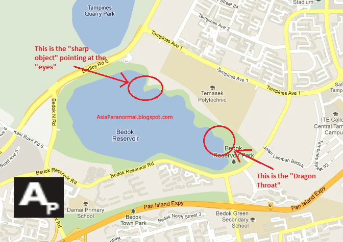
Bedok Reservoir is a is a reservoir located in the eastern part of Singapore. It was completed in 1986. Since 2004, the local authorities have increasingly allowed activities to take place in Bedok Reservoir. These include watersports like wakeboarding, sailing and canoeing. Thus, in recent years, the number of members of the public visiting the reservoir has increased.
In 2011, within a span of 5 months since June, a series of incidents occurred at the reservoir. A total of 5 bodies have been pulled out from the water, leading people to believe that the reservoir is cursed. Is this really the case though? We take a look at the evidence and speculate on the possible explanations for this spate of incidents.
Bedok Reservoir Cursed?
Body found in Bedok Reservoir again, 5th since June
1) Curses
This seems a most likely explanation and the easiest to fall upon though. A curse is a wish expressed upon some other entity – a person, an object or a place. Harm or hurt will be inflicted by supernatural powers.
But is the reservoir cursed? Bedok town was developed in 1973, but evidence shows that a “Bedok River” has existed in Singapore since 1604. In the past, it used to be a hilly area before urban development and was populated mainly by fishermen.
Would anyone place a curse on the reservoir? Remember, it was not completed till 1986. Exactly 25 years later, the spate of incidents occurred. Perhaps someone was unhappy with the construction of the reservoir and placed a curse upon it? Then why would the curse start manifesting itself only after 25 years?
2) Hauntings
Bedok was one of the first few “new towns” developed by the HDB in the 1970s. Past history did not indicate any worthy incidents of note, but way back in 1942, during World War II, the Bedok Hill Massacre occurred.
On the 28th of February 1942, 90 men from the Federrated Malay States Volunteer Force (FMSVF), Straits Settlement Volunteer Force (SSVF) and the Malay Regiment were executed by the Japanese.
Was this the catalyst for the recent spate of accidents and suicides? Were the ghosts of the soldiers somehow enacting their revenge? But why only now? Furthermore they were killed on a hill, which was already been leveled during the town development days in the 1970s. What has that got to do with the reservoir?
3) Earth Magnetic Field
Ley lines are alleged alignments of a number of places of geographical and historical interest, such as ancient monuments and megaliths, natural ridge-tops and water-fords. Experts claim that such lines are the energy pathways of the Earth, and some attribute them to UFO sightings.
But do they exist in Singapore? Perhaps the reservoir lies upon a ley line of negative energy, influencing people into making negative decisions.
Furthermore, psychiatrists too have noticed a correlation between geomagnetic activity and suicide rates.
Geomagnetic storms - periods of high geomagnetic activity caused by large solar flares - have also been linked to clinical depression.
In 1994, a study was published suggesting a 36.2% increase in the number of men admitted into hospital for depression in the second week after geomagnetic storms (British Journal of Psychiatry vol 164, p 403).
What may be the cause of the link, if there is one, remains unknown. Could this be a reason? Do remember that Singapore does not have high geological activity though.
Does the Earth's magnetic field cause suicides?
4) Fengshui
If you take a look at the picture above, it certainly resembles a side view of a male human head. This is due to the resemblance of a "Dragon Throat" or "Adam Apple" near the throat of the head. The Dragon Throat is the vital essence of the accumulating negative "qi".
According to what is indicated in our picture, there is something sharp pointing at the eyes. If someone uses a sharp physical object to point at your eyes, you will be blinded. If someone is blinded, there is a high chance that the person will get into accident.
For example, the person might be blinded and fall into the reservoir. This could explain the recent accidents at the reservoir. The victims might have been "blinded" and "fell" into the reservoir.

- Quoted from Master Orthodox Occultist Oregon Chang
5) Mere coincidences
Finally, perhaps these 5 incidents does have a simple and plausible explanation after all. We think that the following 2 factors influenced the turn of events greatly.
1) Accessibility - The reservoir has been opened to public use for watersports for many years. Also, a lot of people go there for fishing as well. Nearby the reservoir is Bedok Reservoir Park. The whole area is highly accessible to the public with transportation readily available.
2) Previously a alarming rate of suicide attempts were made on MRT tracks, whereby the individual will jump onto the tracks just as the trains were pulling in. However, since the authorities had made renovations to the train stations by building barrier gates and doors, the suicide rates has dropped dramatically.
Put two and two together, we have the most probable answer. As MRT stations are getting less accessible for suicide attempts, coupled with the ease of accessibility of Bedok Reservoir road. People are choosing the reservoir as their choice of suicide attempts.
Unfortunately, this is all just statistics. Compare it to a hospital where almost everyday people die of natural causes or sickness. If only 5 people die in a hospital within 5 months, no one will bat an eyelid. But if 5 people die everyday for 5 months, people will start wondering if there is something wrong with the hospital.
Compare to a busy road with heavy traffic and a lot of pedestrians. Within 5 months, if 5 accidents occur there, some people might think that it is a bit statically little in number. But within 5 months, 5 accidents occur at a reservoir, people start thinking there is something wrong.
Ultimately, this is just a statistical anomaly. Its all about the perception of human beings of statistics. People are just as about likely to die in a reservoir.
International suicide rates are 1 in 121, whereas dying from car accident is 1 in 260. Does this mean a person is more likely to die from suicide than from accidents?
DISCLAIMER: Asia Paranormal does not condone suicidal behavior and actions. We wish to emphasize the fact that life is precious and please, do not recklessly endanger it and cause misery to the people and loved ones around you. If need be, please seek help or counselling. There is always a solution.
Read more >>
Bedok Reservoir is a is a reservoir located in the eastern part of Singapore. It was completed in 1986. Since 2004, the local authorities have increasingly allowed activities to take place in Bedok Reservoir. These include watersports like wakeboarding, sailing and canoeing. Thus, in recent years, the number of members of the public visiting the reservoir has increased.
In 2011, within a span of 5 months since June, a series of incidents occurred at the reservoir. A total of 5 bodies have been pulled out from the water, leading people to believe that the reservoir is cursed. Is this really the case though? We take a look at the evidence and speculate on the possible explanations for this spate of incidents.
Bedok Reservoir Cursed?
Body found in Bedok Reservoir again, 5th since June
1) Curses
This seems a most likely explanation and the easiest to fall upon though. A curse is a wish expressed upon some other entity – a person, an object or a place. Harm or hurt will be inflicted by supernatural powers.
But is the reservoir cursed? Bedok town was developed in 1973, but evidence shows that a “Bedok River” has existed in Singapore since 1604. In the past, it used to be a hilly area before urban development and was populated mainly by fishermen.
Would anyone place a curse on the reservoir? Remember, it was not completed till 1986. Exactly 25 years later, the spate of incidents occurred. Perhaps someone was unhappy with the construction of the reservoir and placed a curse upon it? Then why would the curse start manifesting itself only after 25 years?
2) Hauntings
Bedok was one of the first few “new towns” developed by the HDB in the 1970s. Past history did not indicate any worthy incidents of note, but way back in 1942, during World War II, the Bedok Hill Massacre occurred.
On the 28th of February 1942, 90 men from the Federrated Malay States Volunteer Force (FMSVF), Straits Settlement Volunteer Force (SSVF) and the Malay Regiment were executed by the Japanese.
Was this the catalyst for the recent spate of accidents and suicides? Were the ghosts of the soldiers somehow enacting their revenge? But why only now? Furthermore they were killed on a hill, which was already been leveled during the town development days in the 1970s. What has that got to do with the reservoir?
3) Earth Magnetic Field
Ley lines are alleged alignments of a number of places of geographical and historical interest, such as ancient monuments and megaliths, natural ridge-tops and water-fords. Experts claim that such lines are the energy pathways of the Earth, and some attribute them to UFO sightings.
But do they exist in Singapore? Perhaps the reservoir lies upon a ley line of negative energy, influencing people into making negative decisions.
Furthermore, psychiatrists too have noticed a correlation between geomagnetic activity and suicide rates.
Geomagnetic storms - periods of high geomagnetic activity caused by large solar flares - have also been linked to clinical depression.
In 1994, a study was published suggesting a 36.2% increase in the number of men admitted into hospital for depression in the second week after geomagnetic storms (British Journal of Psychiatry vol 164, p 403).
What may be the cause of the link, if there is one, remains unknown. Could this be a reason? Do remember that Singapore does not have high geological activity though.
Does the Earth's magnetic field cause suicides?
4) Fengshui
If you take a look at the picture above, it certainly resembles a side view of a male human head. This is due to the resemblance of a "Dragon Throat" or "Adam Apple" near the throat of the head. The Dragon Throat is the vital essence of the accumulating negative "qi".
According to what is indicated in our picture, there is something sharp pointing at the eyes. If someone uses a sharp physical object to point at your eyes, you will be blinded. If someone is blinded, there is a high chance that the person will get into accident.
For example, the person might be blinded and fall into the reservoir. This could explain the recent accidents at the reservoir. The victims might have been "blinded" and "fell" into the reservoir.
- Quoted from Master Orthodox Occultist Oregon Chang
5) Mere coincidences
Finally, perhaps these 5 incidents does have a simple and plausible explanation after all. We think that the following 2 factors influenced the turn of events greatly.
1) Accessibility - The reservoir has been opened to public use for watersports for many years. Also, a lot of people go there for fishing as well. Nearby the reservoir is Bedok Reservoir Park. The whole area is highly accessible to the public with transportation readily available.
2) Previously a alarming rate of suicide attempts were made on MRT tracks, whereby the individual will jump onto the tracks just as the trains were pulling in. However, since the authorities had made renovations to the train stations by building barrier gates and doors, the suicide rates has dropped dramatically.
Put two and two together, we have the most probable answer. As MRT stations are getting less accessible for suicide attempts, coupled with the ease of accessibility of Bedok Reservoir road. People are choosing the reservoir as their choice of suicide attempts.
Unfortunately, this is all just statistics. Compare it to a hospital where almost everyday people die of natural causes or sickness. If only 5 people die in a hospital within 5 months, no one will bat an eyelid. But if 5 people die everyday for 5 months, people will start wondering if there is something wrong with the hospital.
Compare to a busy road with heavy traffic and a lot of pedestrians. Within 5 months, if 5 accidents occur there, some people might think that it is a bit statically little in number. But within 5 months, 5 accidents occur at a reservoir, people start thinking there is something wrong.
Ultimately, this is just a statistical anomaly. Its all about the perception of human beings of statistics. People are just as about likely to die in a reservoir.
International suicide rates are 1 in 121, whereas dying from car accident is 1 in 260. Does this mean a person is more likely to die from suicide than from accidents?
DISCLAIMER: Asia Paranormal does not condone suicidal behavior and actions. We wish to emphasize the fact that life is precious and please, do not recklessly endanger it and cause misery to the people and loved ones around you. If need be, please seek help or counselling. There is always a solution.
Thursday, October 20, 2011
Water spout spotted heading towards Tuas

Picture is (C) copyright to STOMP
A water spout was seen over the waters near Johor Baru.
It seemed to be moving in the direction of Tuas, said a witness.
The netizen, Mr Lim, sent in photos of the sight to citizen journalism site Stomp.
He said the water spout took around five minutes to move.
A water spout is a funnel-shaped vortex over water.
It is connected to a cloud and is usually weaker than its land counterparts such as tornadoes.
[Click here to read full article]
Saturday, September 17, 2011
Massive eruptions with static discharge lightning Sakurajima Volcano in Japan on Aug 28 and Sep 1, 2011
Sakurajima volcano in Japan usually shows activity, however large explosions from the caldera like this are more rare.
You can clearly see the lava missiles/projectiles/meteors erupt thousands of feet in the air.
The cars below on the highway are safely out of the way, nonetheless this eruption is a large one.
The first massive eruption happened on Augsut 28, 2011
The second massive eruption happened on Sept 1, 2011 sometimes with very impressive lava flows, or explosions… on the rare occasion you get to see the lightning associated with static discharge and friction in the atmosphere.
Read more >>
You can clearly see the lava missiles/projectiles/meteors erupt thousands of feet in the air.
The cars below on the highway are safely out of the way, nonetheless this eruption is a large one.
The first massive eruption happened on Augsut 28, 2011
The second massive eruption happened on Sept 1, 2011 sometimes with very impressive lava flows, or explosions… on the rare occasion you get to see the lightning associated with static discharge and friction in the atmosphere.
Wednesday, August 10, 2011
Massive meteorite found in China
A massive space rock – one that could rank as one of the largest meteorites ever recovered – has been found in a remote and mountainous region in northwest China, according to news reports.
The huge and oddly-shaped rock was found in the Altai mountains in China's Xinjiang Uygur province, according to Sky and Telescope magazine. Earlier this month, Baolin Zhang, a meteorite specialist at the Beijing Planetarium, led a small team up a 9,500-foot (2,900-meter) summit to investigate reports of the supposed meteorite.
"This is a huge iron meteorite," Zhang said in footage from China Central Television. "It may be the second largest iron meteorite, which can cause a sensation in China and also attract attention from [the] world's meteorite fields. It comes from outside solar system and it is of great appreciating value and of more scientific value."
[Click here to read full article]
Read more >>
The huge and oddly-shaped rock was found in the Altai mountains in China's Xinjiang Uygur province, according to Sky and Telescope magazine. Earlier this month, Baolin Zhang, a meteorite specialist at the Beijing Planetarium, led a small team up a 9,500-foot (2,900-meter) summit to investigate reports of the supposed meteorite.
"This is a huge iron meteorite," Zhang said in footage from China Central Television. "It may be the second largest iron meteorite, which can cause a sensation in China and also attract attention from [the] world's meteorite fields. It comes from outside solar system and it is of great appreciating value and of more scientific value."
[Click here to read full article]
Thursday, August 4, 2011
Explorers find bizarre, spaceship-like object at the bottom of the Baltic Sea
Several days ago, we reported that a Swedish team of shipwreck hunters discovered a strange, circular object at the bottom of the Baltic Sea that looks sort of like the Millennium Falcon. The group was using sonar to plumb the depths of the waters, hoping to find shipwrecks that might contain treasures they could sell. The Ocean Explorer team isn't sure what to make of this strange discovery that some are calling a crashed UFO, but they've released more information about it.
Here you can see Peter Lindberg, from the Swedish Ocean Explorer team that discovered the object, explaining what they found. Earlier, he told reporters:
At 87 meters down, between Sweden and Finland, they saw a large circle, about 60 feet in diameter. You see a lot of wierd stuff in this job but during my 18 years as a professional I have never seen anything like this. The shape is completly round…a circle.
[Click here to read full article]
Read more >>
Here you can see Peter Lindberg, from the Swedish Ocean Explorer team that discovered the object, explaining what they found. Earlier, he told reporters:
At 87 meters down, between Sweden and Finland, they saw a large circle, about 60 feet in diameter. You see a lot of wierd stuff in this job but during my 18 years as a professional I have never seen anything like this. The shape is completly round…a circle.
[Click here to read full article]
Tuesday, July 19, 2011
Indonesia's Mount Lokon Erupts - Right on Schedule!
Mount Lokon, a volcano in central Indonesia, erupted in fury late Thursday, scattering nearby residents and wreaking havoc. But, because volcanologists have become so skilled at predicting eruptions, there were no fatalities. And none are expected.
For more than a week the mountain has been rumbling and scientists warned that an eruption was imminent. In the past such warnings may have gone unheeded until it was too late.
But because geologists now have such advanced prediction equipment at their disposal, and because of vast experience in other parts of the world, this time local officials were able to evacuate the area long before the mountaintop was blown away by the massive explosion.
[Click here to read full article]
Read more >>
For more than a week the mountain has been rumbling and scientists warned that an eruption was imminent. In the past such warnings may have gone unheeded until it was too late.
But because geologists now have such advanced prediction equipment at their disposal, and because of vast experience in other parts of the world, this time local officials were able to evacuate the area long before the mountaintop was blown away by the massive explosion.
[Click here to read full article]
Subscribe to:
Posts (Atom)


